Skip to content
  • Catalogue
  • Dictionary of Irish Architects
  • Catalogue
  • Dictionary of Irish Architects
Menu

Menu

Detail from a Plan of Intended Alterations Proposed to be made at Howth Demesne by John Hill, after Thomas Simpson, from circa 1710.

Plan of Intended Alterations Proposed to be made at Howth Demesne

John Hill, after Thomas Simpson

1740

Ink and colour wash on paper

IAA Howth Castle 2024/14.1/1

Rural Planning I: Country Houses and Landscape

Plan of Intended Alterations Proposed to be made at Howth Demesne

John Hill, after Thomas Simpson

1740

Ink and colour wash on paper

IAA Howth Castle 2024/14.1/1

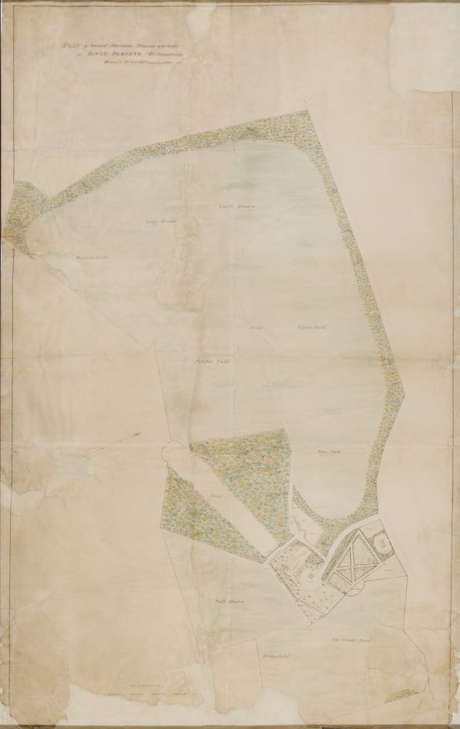
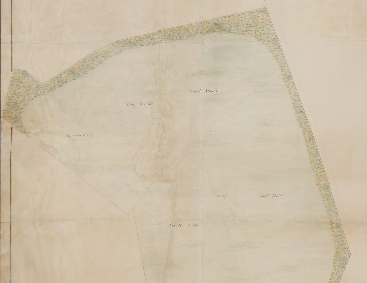
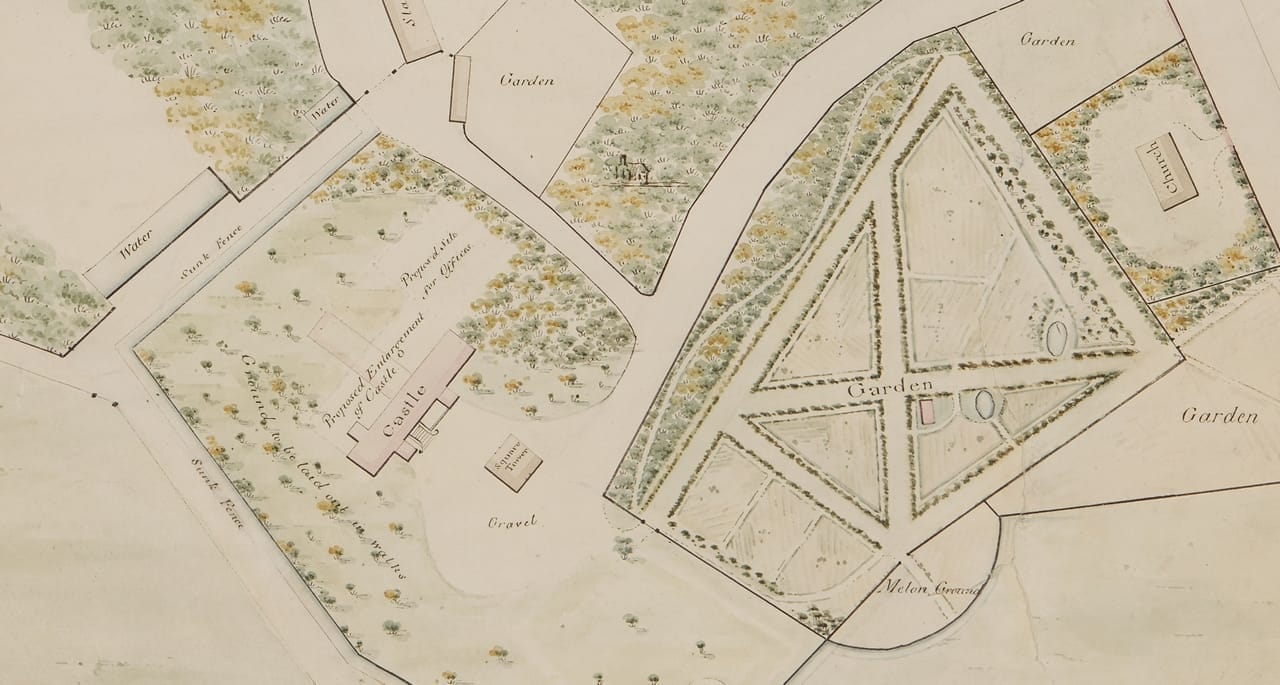
Forming a distinctive part of an estate, a demesne encompasses the principal residence of the landholder and an area of surrounding lands retained exclusively for the landholder’s use. As Irish landholders transitioned away from fortified houses within defensive bawns over the course of the second half of the seventeenth century and first decades of the eighteenth, the nature of Irish demesnes altered. Enclosure walls were removed, new formal gardens laid out, walks and water features developed, and trees planted within demesnes and around their boundaries to create vistas of and from new or enlarged country houses.

All of these trends are clearly discernible in this large drawing produced by the otherwise unknown ‘Surveyor of Lands & Valuer of Estates’ John Hill, recording proposed alterations to Howth Castle Demesne by the also unknown Thomas Simpson. The absence from the drawing of the north and east wings of the castle, and the inclusion of a ‘Proposed Enlargement’ on the site of what would become the west wing from c. 1740, indicate that the drawing was made before alterations and additions carried out for William St Lawrence, 14th Baron Howth.

This drawing was in a very poor condition when it was donated the IAA by Julian Gaisford St Lawrence in 2024. Torn, creased, dirty, and with substantial losses, it has been carefully and meticulously restored by paper conservator Liz D’Arcy in a project made possible by funds bequeathed to the IAA for this very purpose by the late Homan Potterton. Many of the features delineated in the drawing were identifiable on OS maps into the twentieth century and, despite the later transformation of much of the Demesne for golf use, some are identifiable on the ground to this day.

Plan of Intended Alterations Proposed to be made at Howth Demesne by John Hill, after Thomas Simpson, from circa 1710.

Designing the Landscape?

 Finola O’Kane

The clue is in the name. The Irish Architectural Archive (IAA) is not particularly well-endowed with materials for studying the history of Irish designed landscape. Most great demesne plans are to be found in the National Library or Archives of Ireland or in university libraries (Maynooth University for the superlative Leinster estate maps) or they remain in private family archives (the IAA’s Dromana map is another noteworthy exception to this rule). There they are often vulnerable, still hanging on the corridor wall or rolled up in an attic. So to have such a large-scale demesne landscape design drawing in the IAA is wonderful, even if it is one distinguished principally by large areas of green wash (3.1). It is at first glance a landscape remarkably bereft of the filigree patterning of a typical 1740 landscape design, which generally included avenues, bosquets, wildernesses, parterres, walled gardens, canals, follies and statues. Influenced and sometimes even designed by such luminaries as the influential English garden designer Stephen Switzer (1682-1745), Irish landscape design in the first half of the eighteenth century was mostly more ambitious than that depicted in this map. But as a plan of the ‘intended alterations’ to Howth Castle demesne, it does not claim to record what existed nor exactly what had been achieved.

Detail from a Plan of Intended Alterations Proposed to be made at Howth Demesne by John Hill, after Thomas Simpson, from circa 1710.
3.1. Thomas Simpson, Plan of Intended Alterations Proposed to be made at Howth Demesne, c.1740 (IAA Howth Castle Collection 2024/14.1/1). Detail
Photographic copy of a painting by William van der Hagen of Howth Demesne, co. Dublin, from circa 1720-45.
3.2. William van der Hagen, Howth Demesne c. 1720-45 (courtesy of the OPW, Doneraile Court)

The map is but a partial representation of Howth Castle demesne’s true extent, its full reach more easily appreciated from a landscape painting commissioned in the first half of the eighteenth century, where the arc of the St Lawrence demesne reaches far to the east (or the map’s left) to encompass the wilder regions of Howth Head (3.2). Attributed to the Dutch painter William van der Hagen (d. 1745), the painting describes a well-appointed and much-battlemented great house enjoying a great vista to the southwest. Its asymmetric elevation is bookended by medieval towers and the front door’s stubborn axis is reiterated by statues, a circular pond and the insistent curves of the entrance court.  The geometry of this walled entrance rectangle, together with the various towers, moats and ditches, all indicate an earlier bawn structure. Beyond the house a central gravel axis is flanked by strips of green lawn and woodland while in the distance ships make a dignified procession into port. The axis ends interestingly, on the very distant lawns of Leinster House. In contrast, Thomas Simpson’s plan records a scheme which would compromise this Dublin vista by building an awkward ‘Proposed Enlargement of the Castle’ to the garden front, which, if not placed exactly on axis with the front door’s steps, created a long T-shape plan that would have severely shadowed and upset this great vista. (3.3)  The towers probably made any new lateral wings unattractive, and the family liked its old ruins as evidenced by another old ‘Square Tower’ it kept on its front turning circle, where it must have inconvenienced more than a few carriages. The T-plan proposal foreshadowed later extensions of the castle by several hands, including ultimately by Sir Edwin Lutyens (1869-1944), as every St Lawrence generation appears to have respected their family’s longevity by adding rather than taking away. Few parts of the house now enjoy a good connection to the exterior, resulting in not so significant immediate gardens, unusual for a house with which Lutyens was involved.

Detail from a Plan of Intended Alterations Proposed to be made at Howth Demesne by John Hill, after Thomas Simpson, from circa 1710.
3.3. Thomas Simpson, Plan of Intended Alterations Proposed to be made at Howth Demesne, c.1740 (IAA Howth Castle Collection 2024/14.1/1). Detail

But which came first – the painting or the map – or why do they represent different landscapes? The walled gardens in both agree nicely, with the map’s oddities (a small building beside the central cross, the extent of the walls within walls, unusual for an already secure enclosure), replicated exactly in the painted view. Three ranges of service buildings are shown in the painting, none of them particularly formal, and the cranked stable building appears in both. Were the service ranges built to occupy the map’s ‘Propos’d Site for offices’ or were older offices kept? The bare single lines of trees that dot all the painting’s walls are logically the precursors to Thomas Simpson’s tree belts, their sinuous curves betraying later sensibilities and fashions. More William Kent than Capability Brown, they nevertheless speak to a new concept of nature and of how plants and trees should or should not be marshalled by design. Key ruins and buildings are omitted from the map with the old castle in the painting’s upper right-hand field absent from the map’s ‘Castle Field’ and the well-restored old church but a scratchy ruin in Simpson’s map. How did Simpson stand on ruins – did he wish to conserve them or to have them erased? But perhaps the main giveaway of his purpose is the green wash and the insistent use of the word field – the principal alteration is agricultural, how the fields are to be used and the potatoes divided from the deer.

How to respond to this item’s nominated theme of rural planning, country houses and landscape and its implication that one of the purposes of country houses and their landscapes was to achieve a planned rural environment? Country houses and their accompanying landscapes may indeed reveal the overall logic or intention of rural planning, but did the country house engender the landscape design or was it more the contrary, that the landscape’s design inspired the form, and most certainly the position, of the country house and by extension its village, churches, public buildings, and estate housing (3.4). Architecture likes to imagine itself as the point of origin, the figure set against a landscape. What if it is the reverse, and the architecture is mere staffage in the painting or the plan?

Irish architecture has moved quite far from the world of the country house. No elevation of a country house graces, or perhaps upsets, this survey of moments and movements. Instead, Ireland is a country built by architects for the people, one where industrial, health, planning and infrastructural demands have replaced the singular house, this type set in a formidable landscape. Yet the one-off house for sixteenth, seventeenth, eighteenth and most of nineteenth-century Ireland, particularly in the countryside, and particularly for those with money, was the place where, arguably, the greatest innovations in Irish architecture and design took place.


Professor Finola O’Kane is Professor in the School of Architecture, Planning and Environmental Policy, University College Dublin. She researches the designed landscape history of Ireland and of the Atlantic world, with a particular interest in the cultural, philosophical and aesthetic dimensions of this history.


Aerial photograph of Howth Demesne., Co. Dublin, from 1950.
3.4 Aerial photograph of Howth Demesne. 1950 (IAA Photograph Collection 2/23 V1)

Donate

Large or small, every donation helps secure the future of the collection. We are truly grateful for your support.

Donate now

Donate

Large or small, every donation helps secure the future of the collection. We are truly grateful for your support.

Donate now

Follow us

  • Facebook
  • Instagram
  • Linkedin

Address

45 Merrion Sq.
Dublin 2
D02 VY60

Contact

01 663 3040
info@irisharchitecturalarchive.ie

English | As Gaeilge

  • English

Opening Hours

Reading Room

10am-5pm, Tuesdays to Fridays; Mondays by appointment

Exhibitions

10am-5pm, Mondays to Fridays

Newsletter

Stay in touch, receive updates about exhibitions and events

Subscribe

English | As Gaeilge

Menu
  • Catalogue
  • Dictionary of Irish Architects
  • About Us
    • About
    • Board
    • Members
    • Staff
    • Annual Reports
    • Contact
  • Our Collections
    • Collections
    • Online Catalogue
  • Our Exhibitions
    • Current Exhibitions
    • Past Exhibitions
  • Our Building
    • No. 45 Merrion Square
    • Venue Hire
  • Access
    • Visit
    • Reading Room
  • Support us
    • Donate
    • Major Sponsors
Search this site

Subscribe

* indicates required

The Irish Architectural Archive will use the information you provide on this form to send you its regular Newsletter. Please confirm that you would like to hear from us:

You can change your mind at any time by clicking the unsubscribe link in the footer of any email you receive from us, or by contacting us at info@iarc.ie. We will treat your information with respect. By clicking below, you agree that we may process your information in accordance with these terms.

We use Mailchimp as our marketing platform. By clicking below to subscribe, you acknowledge that your information will be transferred to Mailchimp for processing. Learn more about Mailchimp's privacy practices.

  • English