Skip to content
  • Catalogue
  • Dictionary of Irish Architects
  • Catalogue
  • Dictionary of Irish Architects
Menu

Menu

Dromana Estate Map from 1751 by Henry Jones.

Dromana Estate Map

1751

Henry Jones

Ink and colour wash on paper

IAA 97/73

Rural Planning II: Towns

Dromana Estate Map

1751

Henry Jones

Ink and colour wash on paper

IAA 97/73

This ‘Plan of Dromana’ was produced in 1751 for John Villiers (c. 1684 -1766), first Earl Grandison, by the otherwise unknown Henry Jones. The map details the demesne of Dromana and the village of Villierstown, Co. Waterford, and is unusual in the number and detail of the architectural elevations with which it is adorned.

Grandison, known as ‘Good Earl John’, was an improving landlord who had the village of Villierstown constructed on his estate specifically as a centre for linen manufacture. Across the top of the map is shown the neat row of village houses built to accommodate the northern linen workers who were to be brought to the village to help establish the new industry on a sound footing. At the centre is an inn, presumably required to accommodate the merchants and traders who would flock to the village to deal in the locally produced linen. This experiment in social engineering ultimately failed, and linen production never thrived in the area. However, Villierstown found other ways to survive and, although few of the buildings are recognisable from the map, it remains one of the neatest of the planned estate villages in Ireland.

Dromana Estate Map from 1751 by Henry Jones.

A Plan of Dromana

 Livia Hurley

 A fundamental tool to make sense of the world at various scales, a map captures topographic space while also serving as a vessel of memory, archiving a particular moment in time with the detail of landscapes, buildings, boundaries and routes that may have long since been altered or erased. In Map, one of WisÅ‚awa Szymborska’s final poems – a meditation on the distance between representation and reality – the poet critiques the comforting illusion of order that is created when we attempt to control and simplify our world through the abstraction of a map. She confesses her affection for them is based on how they might deceive us:


I like maps, because they lie.
Because they give no access to the vicious truth.
Because great-heartedly, good-naturedly
they spread before me a world
not of this world’.(1)

All of the above applies in some way to the Plan of Dromana made in 1751 by the surveyor Henry Jones, in the so-called French School style of cartography, a relatively new method of estate mapping in Ireland at that point.(2) Jones’s highly graphic survey of the demesne at Dromana and the neighbouring village of Villierstown, Co. Waterford, illustrates the ambitions of its landowners, the Villiers family, providing a snapshot of the improvement and development of a typical estate during the aspirational years of the Enlightenment.


Described on the map as ‘a new and neat Colony erected … for the advancement of the Linen Manufacture…’, Dromana reminds us that this was a country on the cusp of an economic boom with emergent textile industries. It was also a period of social engineering grounded in a theory that environments could challenge and shape the behaviour of inhabitants, and this could be accomplished towards socially progressive ends. The map presents us with the carefully delineated and colour-washed landscapes of the estate, with its mansion perched on the promontory above a busy River Blackwater, its gardens and oak plantations filling in space between bluff and boundary, and its avenue winding through the grounds to connect the landlord with his village like a long piece of string. Drawings here of estate labourers in full garb, grouped with their animals and implements, were quite unique in eighteenth-century Irish cartography, underscoring the ideology of a utopian world (4.1). Can this map be read as an exact representation of what was on the ground or is it a fantasy? In truth it’s a hybrid: part record, part proposal. Accepting the fact that an east-west orientation has been favoured to depict the demesne from the river, when Dromana is compared with evidence from the first-edition Ordnance Survey map (1839-41), landscapes and boundaries appear to have been minutely observed and recorded. The same could be said for most of the principal demesne features and its architecture, illustrated in a series of slightly crude vignettes lining the edge of the map, and catalogued in a key in one of Jones’s baroque cartouches.

Deatail from A Plan of Dromana by Henry Jones from 1751 showing a herder in native garb with his cattle.
4.1 Henry Jones, A Plan of Dromana, 1751 (IAA 97/73). Detail
Deatail from A Plan of Dromana by Henry Jones from 1751 showing plan of Villerstown, Co. Waterford.
4.2 Henry Jones, A Plan of Dromana, 1751 (IAA 97/73). Detail

But that gap between real and imagined space is tested in the plan for the new industrial village at Villierstown and the housing for émigré linen weavers. Drawn by Jones as two right-angled streets lined with weavers’ houses interconnected with screen walls, it had a market house at its junction and a chapel closing a tree-lined allée off the main street (4.2). A second set of ‘tradesmens houses’ (their highly formal designs seemingly acquired from pattern books) and an inn for temporary workers were also planned for a green within the demesne, revealing the quixotic nature of the proposal.(3) As it turned out, the linen industry at Villierstown only lasted a decade, the market house was never built – the church was constructed on its site instead – and only a small number of the houses were completed. This section of the map might be perceived as a deceit, a fiction, but sketches, drawings and design proposals are just that, fictitious, until they are fully realised. What matters here is the aspiration at Villierstown to construct its geography into a highly formal settlement supported by specific socio-economic conditions.

Irish eighteenth-century settlement, both planned and remodelled, was largely designed as a kind of studied formalism where urban footprints were laid out with vistas framed by public buildings, malls were lined with terraced street fronts, squares and greens expanded the plan at regular intervals, and a sense of symmetry and rigour pervaded throughout.(4) Configurations varied from the rigid linear form – for instance at Cookstown, Co. Tyrone, and Strokestown, Co. Roscommon (4.3) – to the elliptical common at Tyrellspass, Co. Westmeath; from triangular greens like Malin, Co. Donegal, to the striking grid-iron pattern of Fermoy, Co. Cork. Squares were either large civic spaces in towns like Birr, Co. Offaly, and Mitchelstown, Co. Cork, or layered like the sloping central diamonds at Clones, Co. Monaghan and Monaghan town. Spatial expression was defined by the axial arrangement of those totems of Irish provincial architecture: church, market house, courthouse, and demesne gates. In the post-1760 decades, while layouts continued to follow classical principles, new village types emerged at sites like Johnstown, Co. Kildare, Westport, Co. Mayo, Stratford-on-Slaney, Co. Wicklow, and Slane, Co. Meath (4.4), where crescents and octagons produced a more dynamic space within which public life rotated.


Aerial photograph of Strokestown, Co. Roscommon, taken in 1970.
4.3 Aerial view of Strokestown, Co. Roscommon, 1970 (IAA BKS Collection, 96/96.138361)
Photograph of Slane, Co. Meath, taken circa 1890
4.4 Slane, Co. Meath, c. 1890 (IAA Photograph Collection, 8/98 V2)

Along with flour and alcohol industries, textile production reinforced much of the country’s industrial network. Its relocation away from larger cities to the countryside was encouraged and supported by the government. New linen colonies emerged at Ballyhaise, Co. Cavan, Inishannon, Co. Cork, Monivea, Co. Galway, and Castlewellan, Co. Down; all more or less contemporaneous with Villierstown.(6) Not all of these industrial enterprises were entirely successful and it would be the next century before more effective models emerged, most of them created by industrialists focussing on the combination of workers’ accommodation with social infrastructure, incorporating the principles of utopian socialism. Two of these settlements based on cotton manufacture, at Bessbrook, Co. Armagh (4.5), and Portlaw, Co. Waterford, were shaped and driven by their Quaker owners. The notion of utopia was ever-present in the Quaker’s ethical outlook and social philosophy but their desire to establish themselves as the new middle-class in Irish society also played a significant role. Portlaw, not too far from Dromana, was developed in three phases between 1825 and 1870; in its most radical reworking the central terraces were swept away in lieu of a baroque polyvium configuration (4.6), with triangular blocks of low-slung housing bookended by commercial structures, all converging on a geometrically ordered market square. The composition of this footprint produced a long and narrow allotment plot for each house, underpinning ideas around self-sufficiency, while also creating a private domestic realm for the workers.


Photograph of College Square North, Bessbrook, Co. Armagh, taken by Livia Hurley in 2018.
4.5 College Square North, Bessbrook, Co. Armagh, 2018 (Livia Hurley)
Oblique aerial photograph from the Historic England Aerofilms Collection showing Portlaw, Co. Waterford, taken facing south west in 1933.
4.6 Oblique aerial photograph of Portlaw, Co. Waterford, taken facing south west, 1933 (Historic England Aerofilms Collection XPW042352 ©Historic England).

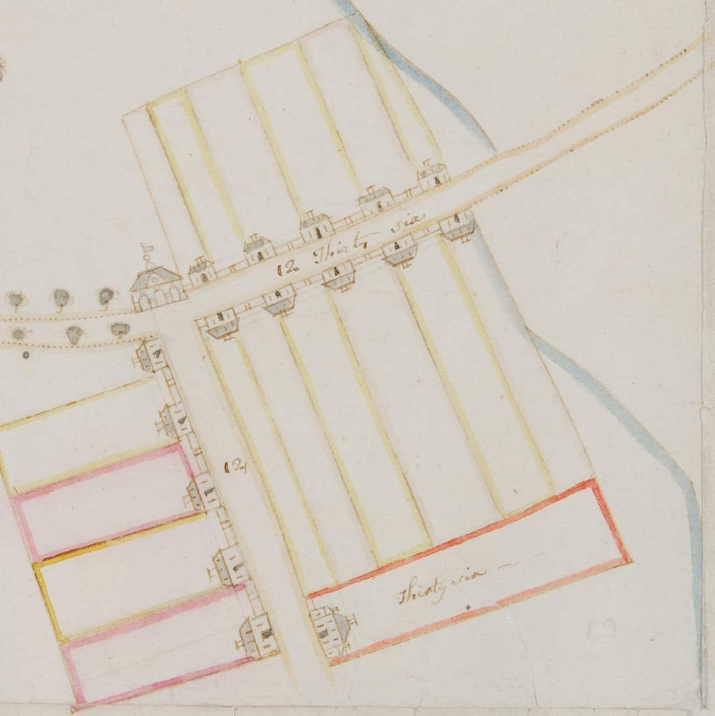
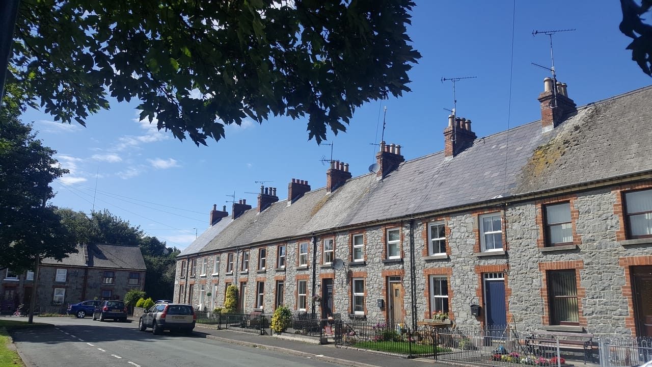
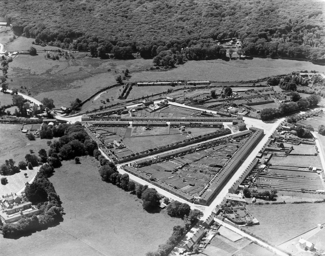
While the demesne gates are swapped for factory gates, there are certain parallels in the ground plan with the proposal at Villierstown: specifically, the axial routes, the rhythm of the terraces, and the ratio between house and garden. The utopian ambition of these industrialists was ideological and sometimes flawed; perhaps too speculative, too tightly bound up in a moral code. But equally it was optimistic and expectant, driven by a social consciousness to work towards a common goal for a better space. When a world is constructed with the aim of shaping others to conform to a particular and personal vision, there turns out to be much more to it than just that vision. In these later Irish villages, it was intended to create an improved environment that was non-sectarian and non-denominational despite the doctrine of its founders. These were important foundations to build upon.


Szymborska hints at a kind of control and containment too when she describes the artificial stillness of a map; its flatness juxtaposed with the vibrant world it represents, and its complexity distilled into two dimensions for our convenience:

Flat as the table
it’s placed on.
Nothing moves beneath it
and it seeks no outlet.
Above – my human breath
creates no stirring air
and leaves its total surface
undisturbed.(6)

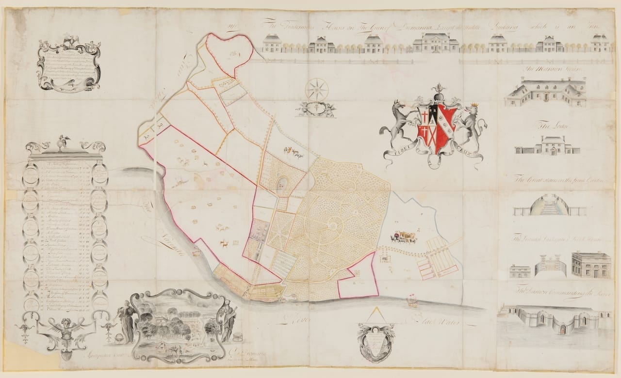
Luckily for us, the Plan of Dromana has also been flattened; its original manuscript form – once folded into sixteen linen-backed pieces – has been opened up, conserved and framed behind glass for public display. The historical artefact is reconstructed as an artwork; not just a geographical document but a unique visual record of the habitus of a particular culture and time.


Footnotes:

1 Wisława Szymborska, Map: Collected and Last Poems, trans. Clare Cavanagh (New York, 2016), 432.

2 Anne Casement, ‘Henry Jones’ 1751 plan of Dromana and its place in the cartographic history of Ireland’, The Local Historian: Journal of the British Association for Local History, Vol. 49, No. 4 (October 2019), 301-316.

3 Edward McParland, Public Architecture in Ireland, 1680-1760 (New Haven & London, 2001), pp. 23-4.

4 For a fuller account see Livia Hurley and Kevin Whelan, ‘Planning of Towns and Villages from the Seventeenth to the Nineteenth Century’, Rolf Loeber, Hugh Campbell, Livia Hurley, John Montague and Ellen Rowley eds, Architecture, 1600-2000: Art and Architecture of Ireland, Vol. IV, (New Haven & London, 2014), 393-97; and Valerie Mulvin, Approximate Formality: Morphology of Irish Towns (Dublin, 2021).

5 Louis Cullen, The Emergence of Modern Ireland, 1600-1900 (London, 1981), 72-76.

6 Wisława Szymborska, Map: Collected and Last Poems, trans. Clare Cavanagh (New York, 2016), 432.


Livia Hurley is a graduate of the School of Architecture at TU Dublin and has a PhD in architectural and urban history from University College Dublin. Her practice encompasses research, writing, conservation and teaching, and she has lectured and published widely on architecture in Ireland.


Donate

Large or small, every donation helps secure the future of the collection. We are truly grateful for your support.

Donate now

Donate

Large or small, every donation helps secure the future of the collection. We are truly grateful for your support.

Donate now

Follow us

  • Facebook
  • Instagram
  • Linkedin

Address

45 Merrion Sq.
Dublin 2
D02 VY60

Contact

01 663 3040
info@irisharchitecturalarchive.ie

English | As Gaeilge

  • English

Opening Hours

Reading Room

10am-5pm, Tuesdays to Fridays; Mondays by appointment

Exhibitions

10am-5pm, Mondays to Fridays

Newsletter

Stay in touch, receive updates about exhibitions and events

Subscribe

English | As Gaeilge

Menu
  • Catalogue
  • Dictionary of Irish Architects
  • About Us
    • About
    • Board
    • Members
    • Staff
    • Annual Reports
    • Contact
  • Our Collections
    • Collections
    • Online Catalogue
  • Our Exhibitions
    • Current Exhibitions
    • Past Exhibitions
  • Our Building
    • No. 45 Merrion Square
    • Venue Hire
  • Access
    • Visit
    • Reading Room
  • Support us
    • Donate
    • Major Sponsors
Search this site

Subscribe

* indicates required

The Irish Architectural Archive will use the information you provide on this form to send you its regular Newsletter. Please confirm that you would like to hear from us:

You can change your mind at any time by clicking the unsubscribe link in the footer of any email you receive from us, or by contacting us at info@iarc.ie. We will treat your information with respect. By clicking below, you agree that we may process your information in accordance with these terms.

We use Mailchimp as our marketing platform. By clicking below to subscribe, you acknowledge that your information will be transferred to Mailchimp for processing. Learn more about Mailchimp's privacy practices.

  • English