Skip to content
  • Catalogue
  • Dictionary of Irish Architects
  • Catalogue
  • Dictionary of Irish Architects
Menu

Menu

Profile of a proposed Kilkenny canal

George Joyce

12 January 1801

Ink and colour washes on paper

IAA Ormond Collection 77/9.85

Building for Transport I: Canals

Profile of a proposed Kilkenny canal

George Joyce

12 January 1801

Ink and colour washes on paper

IAA Ormond Collection 77/9.85

A Kilkenny Canal

Rob Goodbody

Proposals for new canals were legion in eighteenth-century Ireland, though implementation was often lacking. The capacity of canals to transport goods was a very tempting proposition in this period as substantially greater loads could be carried with greater ease along canals than by roads, opening up new opportunities for trade and manufacturing (7.1). Cost, however, were a major disadvantage. To address these, the Irish parliament gave grants towards the construction of canals and from 1755 these sums could be significant.(1)

With the benefit of this funding, a canal was proposed in the 1750s to connect Kilkenny city with tidal waters at Inistioge, Co. Kilkenny, and work was commenced at the city end.(2) Work came to a halt a little to the south of Bennettsbridge, Co. Kilkenny, and never recommenced, ensuring that the section that had been built was of little use as the area beyond it to Inistioge was not navigable. This short canal was not in use for long, though much of it is still traceable on the ground.

Undeterred by this failure, the Earl of Ormond engaged canal engineer William Chapman to carry out surveys with a view to the construction of a canal from Kilkenny to Thomastown.(3) His report, with detailed costings, was produced in 1787 and was the basis of an application to parliament for the legislation necessary to construct the canal.(4) However, the necessary procedures were not undertaken and the bill was withdrawn.(5)

Photograph of the Newry Canal, Co. Down, taken circa 1970.
7.1 Newry Canal, Co. Down, c. 1970 (IAA Photograph Collection 30/54 V1)
Photograph of a rrawbridge on Grand Canal at Monasterevin, Co. Kildare, taken in 1978.
7.2 Drawbridge on Grand Canal, Monasterevin, Co. Kildare, 1978 (IAA Survey Photograph 29/22 Z4)

William Chapman then re-examined the proposal for a canal, comparing a route alongside the river Nore with an alternative route running eastwards via Gowran and Goresbridge, Co. Kilkenny, to join the river Barrow.(6) This would be a much shorter route to the Dublin markets and would still provide a route to Waterford, though somewhat longer than down the Nore. The committee responsible for pursuing the canal project then engaged a Mr Semple to survey the route through Gowran.(7) The identity of Mr Semple is unclear, but it may have been John Semple, a Co. Carlow engineer who is recorded as active in the 1790s.(8) This project was not pursued further at this time.

Meanwhile, other canal projects were being considered elsewhere. These included a proposal by the gentlemen of Queen’s County, now Laois, for a canal linking the Grand Canal at Monasterevin, Co. Kildare (7.2), to Maryborough (Portlaoise) and Mountmellick, Co. Laois, surveyed by the engineer John Killaly. A second canal to connect Maryborough with the coalfields near Castlecomer, Co. Kilkenny, was surveyed by Mitchell Sparks, engineer. Reports for these schemes were produced in the summer of 1800.(9) In September of that year a committee resolved to pursue the project and by the following March it had received an offer of a grant from the Directors General of Inland Navigation amounting to half of the cost of constructing a canal, by now being referred to as the Colliery Canal.(10)

Spurred by this proposal for a canal reaching the northern part of county Kilkenny, the gentlemen of that county once again looked at the potential for a canal and engaged engineer George Joyce to survey alternative routes. In January 1801 he produced his report with a map, examining three potential lines for a canal (7.3).(11)

The first route examined was to connect the proposed Colliery Canal, which Joyce called the Queen’s County Canal, to the Nore at Thomastown, Co. Kilkenny. The alignment ran southward to the eastern suburbs of Kilkenny, before turning eastward, well away from the Nore to reach Thomastown, following which the canal was to continue down the eastern side of the river to Inistioge.

The second route followed the same line from the north as far as the Nore at Kilkenny, beyond which it was to run alongside the Nore, entering the river at some locations where it was navigable.

The third route was a potential branch line running eastward past Gowran to join the river Barrow at Goresbridge, which Joyce called Newbridge.

In his report, Joyce goes into great detail on the eastern route to be followed from the northern end where it would join the Colliery Canal, through the city suburbs, onward to Thomastown, and then downriver to Inistioge. He mentions every cutting and embankment and each of the proposed canal locks, though few bridges or aqueducts are noted. The precise alignment is difficult to follow without detailed knowledge of the history of the area, as many of the landmarks he provides along the route are simply houses named for their then occupiers, such as ‘leaving Mr. Lawlor’s house to the left’.

The information he provides for the route alongside the Nore is not as detailed, while the route to connect with the Barrow is a single sentence – ‘I have also taken the levels from Abbeygrove to the river Barrow, by Gowran and Newbridge, &c.’ This lack of detail on the Barrow route is explained by his dismissal of this as a viable proposition: ‘The plan and section will, I trust, explain the impracticality of this branch, with the enormous expense of carrying it into execution’.

Map entiteld Sketch of the Country Through which it is Proposed to run a Canal…, engraved by J. Taylor, Dublin, in 1802.
7.3 George Joyce, Sketch of the Country Through which it is Proposed to run a Canal…, engraved by J. Taylor, Dublin, 1802 (IAA Institute of Engineers of Ireland Collection 2025/095.573 Appendix III, map)

An important element that Joyce does not clarify is the connection between the eastern route of the canal and the Nore at Kilkenny. The small-scale map of the proposed routes shows a link which would have been necessary if the canal was to continue southward alongside the Nore rather than by the eastern route. Whether this link would have been provided if the option to the east had been followed is unclear and there is no mention of it in his report. Either way, the connection to the Nore would have required locks to lower the canal down to the level of the river and these are not shown on either the small-scale plan or the profile drawing and the cost of building them is not included in his estimates.

Joyce depicted long sections of his three suggested canal routes on a single profile drawing.(12) The route from the proposed Colliery Canal to Inistioge is shown on the upper part of the sheet and the route alongside the Nore from Kilkenny to Thomastown and the route connecting to the Barrow are on the lower part. The profile drawings are summaries of the proposals, indicating the locations where the canal levels rise or fall. One of the locks needed to achieve these changes is detailed by Joyce on a separate drawing (7.4).

Draring by George Joyce showing the ground plan of lock and weir dated 1801.
7.4 George Joyce, Ground Plan of Lock & weir with Moving cloughs, 1801 (IAA Ormond Collection 79/9.86)
Detail from George Joyce's profile drawing of aproposed canal dated 1801.
7.5 George Joyce, Profile of the proposed Line of Canal…, 1801 (IAA Ormond Collection 79/9.85). Detail.

As is usual with profile drawings such as these, the vertical scale is greater than the horizontal to provide a clearer image. In this case the vertical scale is 16½ times the horizontal scale. The existing ground level is shown by a thick black line with shading below it and the proposed canal by a blue band (7.5). Anything below the blue line of the canal and above the existing ground level represents an embankment, while anything above the bottom of the blue line of the canal and below the black line is a cutting.

To the south of Kilkenny, to the right of the title at the top of the drawing, two blue lines are shown, one above the other (7.6). The two are alternative alignments, the lower one illustrating Joyce’s argument that this option would require a very long and very deep cutting at a substantial cost. The two alternatives also appear on the profile drawing of the route to the Barrow.

A canal needs an ample supply of water and the upper option would have required diverting a number of small streams to feed the canal. If any assessment was carried out by Joyce to determine the impact this might have on agricultural and domestic holdings dependent on these streams, it is not recorded. Also missing from Joyce’s proposals is a proper cost-benefit analysis of the canal. He includes merely the costs. Fourteen years earlier, however, William Chapman had provided estimates of the projected annual use of the canal then proposed from Kilkenny to Inistioge.(13) He had calculated that 1,000 tons of marble would be brought down the canal each year and 15,000 tons of agricultural produce, while goods brought up the canal would amount to 6,000 tons, including timber, iron, coal and other commodities.

The Kilkenny Canal project never proceeded. Moves to construct the Colliery Canal continued until 1809 before disappearing, while the Grand Canal Company built the branch as far as Mountmellick in the 1820s.(14) In the 1830s Richard Griffith carried out a survey and prepared a proposal for a canal from Kilkenny to Inistioge, but it also did not proceed.(15) Sporadic letters to newspapers continued to argue for the Kilkenny Canal and the Colliery Canal well into the railway age, while the earlier line between Kilkenny and Bennettsbridge remained unused and derelict.(16) Perhaps the greatest surviving element of this abortive project is George Joyce’s nearly five-metre long profile drawing.

Detail from George Joyce's profile drawing of aproposed canal dated 1801.
7.6 George Joyce, Profile of the proposed Line of Canal…, 1801 (IAA Ormond Collection 79/9.85). Detail.

Footnotes:

1 Ruth Delany, A Celebration of 250 Years of Ireland’s Inland Waterways (Dublin, 1992) 13.

2 Delany, A Celebration, 67.

4 William Chapman, ‘Report of William Chapman, Engineer, on the Practicability and Expense of making a Navigable Canal from Thomastown to Kilkenny, 1787’, William Tighe, Statistical Observations relative to the County of Kilkenny (Dublin, 1802), appendix I, 3-22.

5 Finn’s Leinster Journal, 29 December 1792, 1.

6 Finn’s Leinster Journal, 30 March 1793, 4.

7 William Chapman, ‘Report on Lines of Navigation from Kilkenny’, Tighe, Statistical Observations, appendix II, 25-30.

8 Finn’s Leinster Journal, 17 August 1796, 1.

9 Dictionary of Irish Architects entry on John Semple (dia.ie).

9 John Killaly, ‘Mr John Killaly’s Report’,1800, Tighe, Statistical Observations, appendix IV, 63-64; Mitchell J. Sparks, ‘Report on the Colliery Canal from Maryborough to Castle-Comer’, Tighe, Statistical Observations, appendix IV, 65-71.

11 Henry Parnell, ‘Letter from Henry Parnell Esq to the Chairman of the Meeting of the Subscribers to the Colliery Canal’, 1801, Tighe, Statistical Observations, appendix VI, 91-106.

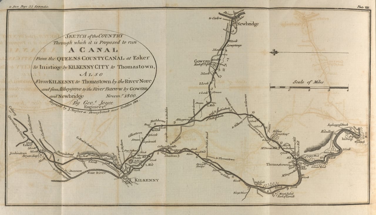
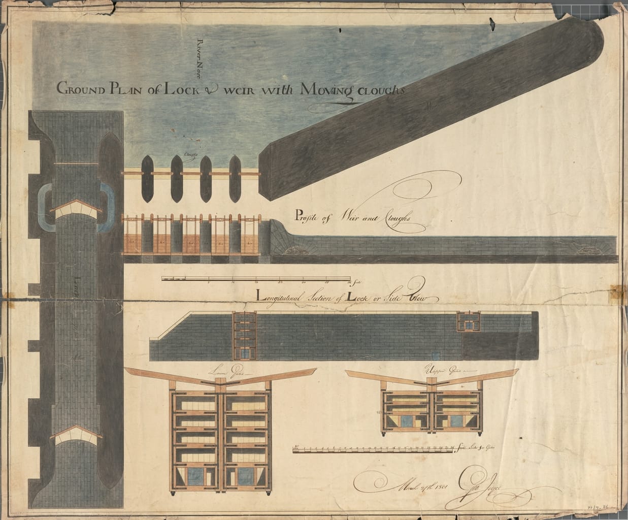
12 George Joyce, ‘Report of the Proposed Canal from the Colliery Canal to the Tide Water at Innistioge’, Tighe, Statistical Observations, appendix III, 31-47.

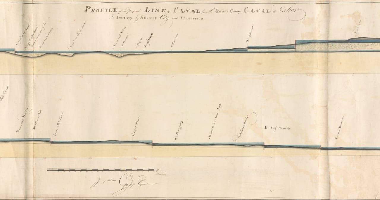
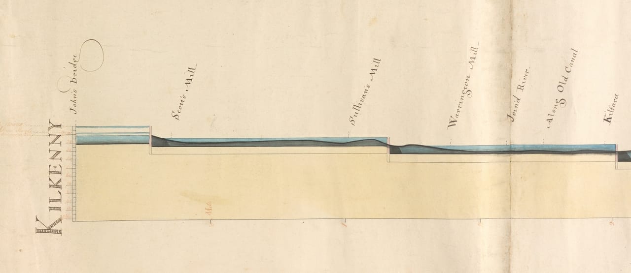
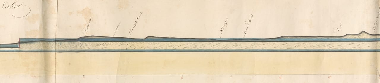
13 George Joyce, Profile of the proposed Line of Canal from the Queen’s County Canal at Esker …, Ormond Collection, IAA 77/9.84-86.

14 Chapman, ‘Report on Lines of Navigation’, 12.

15 Freeman’s Journal, 18 November 1809, 2; Ruth Delany, The Grand Canal of Ireland (Dublin, 1995), 94-95.

16 Freeman’s Journal, 25 November 1833, 3.

16 For example, Freeman’s Journal, 30 January 1829, 3; Kilkenny Journal, 5 September 1838, 2; Kilkenny Monitor, 21 August 1850, 2.


Rob Goodbody is a historic building consultant. He is currently President of the Industrial Heritage Association of Ireland.

Donate

Large or small, every donation helps secure the future of the collection. We are truly grateful for your support.

Donate now

Donate

Large or small, every donation helps secure the future of the collection. We are truly grateful for your support.

Donate now

Follow us

  • Facebook
  • Instagram
  • Linkedin

Address

45 Merrion Sq.
Dublin 2
D02 VY60

Contact

01 663 3040
info@irisharchitecturalarchive.ie

English | As Gaeilge

  • English

Opening Hours

Reading Room

10am-5pm, Tuesdays to Fridays; Mondays by appointment

Exhibitions

10am-5pm, Mondays to Fridays

Newsletter

Stay in touch, receive updates about exhibitions and events

Subscribe

English | As Gaeilge

Menu
  • Catalogue
  • Dictionary of Irish Architects
  • About Us
    • About
    • Board
    • Members
    • Staff
    • Annual Reports
    • Contact
  • Our Collections
    • Collections
    • Online Catalogue
  • Our Exhibitions
    • Current Exhibitions
    • Past Exhibitions
  • Our Building
    • No. 45 Merrion Square
    • Venue Hire
  • Access
    • Visit
    • Reading Room
  • Support us
    • Donate
    • Major Sponsors
Search this site

Subscribe

* indicates required

The Irish Architectural Archive will use the information you provide on this form to send you its regular Newsletter. Please confirm that you would like to hear from us:

You can change your mind at any time by clicking the unsubscribe link in the footer of any email you receive from us, or by contacting us at info@iarc.ie. We will treat your information with respect. By clicking below, you agree that we may process your information in accordance with these terms.

We use Mailchimp as our marketing platform. By clicking below to subscribe, you acknowledge that your information will be transferred to Mailchimp for processing. Learn more about Mailchimp's privacy practices.

  • English